
-
-
A Study on Temperature Reduction Characteristics of Coated Rails Considering Correlation with Ambient Temperature
대기온도와의 상관성을 고려한 차열도료 도포 레일의 온도 저감 특성 연구
-
Jinseong Park, Hyuksang Jung, Seongmin Jang, Tran Hamy
박진성, 정혁상, 장성민, 짠하미
- As the frequency of summer heatwaves increases due to recent global warming, the risk of track buckling caused by rising rail temperatures …
최근 지구 온난화로 인한 하절기 폭염 발생 빈도 증가에 따라 장대레일의 궤도 장출(Buckling) 사고 위험이 가중되고 있다. 본 연구에서는 50 kg 레일을 …
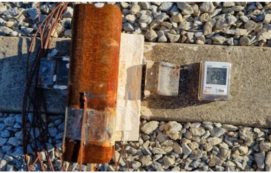
- As the frequency of summer heatwaves increases due to recent global warming, the risk of track buckling caused by rising rail temperatures in Continuous Welded Rail (CWR) is intensifying. In this study, the temperature reduction effect of thermal barrier paint was empirically analyzed through indoor simulation experiments using 50 kg rails, and a management standard for ambient temperature was proposed based on the correlation between ambient and rail temperatures. The uncoated rail temperature was measured up to 18.6 °C higher than the ambient temperature during peak hours, while the application of thermal barrier paint resulted in an average reduction of 1 to 2 °C and a maximum reduction of over 5 to 6 °C. A unified regression model incorporating position-specific correction variables (α) was proposed based on high linear correlation (R2 ≥ 0.90). The critical ambient temperature was calculated at approximately 52~53 °C for uncoated rails, increasing to approximately 54~59 °C with thermal barrier paint application, representing a delay of up to 7 °C. These findings are expected to serve as quantitative data for summer railway maintenance and intelligent track temperature prediction systems.
- COLLAPSE
최근 지구 온난화로 인한 하절기 폭염 발생 빈도 증가에 따라 장대레일의 궤도 장출(Buckling) 사고 위험이 가중되고 있다. 본 연구에서는 50 kg 레일을 대상으로 실내 모사 실험을 통해 차열도료의 온도 저감 효과를 실증적으로 분석하고, 대기온도와 레일 온도 간의 상관관계를 토대로 관리 기준 대기온도를 제안하였다. 분석 결과, 피크 시간대 미도포 레일은 대기온도 대비 최대 18.6 ℃ 높게 측정되었으며, 차열도료 도포 시 평균 1~2 ℃, 최대 5~6 ℃ 이상의 저감 효과가 나타났다. 대기온도와 레일 온도 간의 높은 선형 상관성(R2 ≥ 0.90)을 바탕으로 부위별 보정 변수(α)를 적용한 통합 회귀 모델을 제안하였으며, 레일 운행 중지 임계치(64 ℃) 기준 관리 대기온도는 미도포 레일 약 52~53 ℃, 도포 레일 약 54~59 ℃로 최대 7 ℃의 임계 시점 지연 효과가 도출되었다. 본 연구 결과는 하절기 철도 유지관리 및 지능형 궤도 온도 예측 시스템 구축을 위한 정량적 기초 자료로 활용될 것으로 기대된다.
-
A Study on Temperature Reduction Characteristics of Coated Rails Considering Correlation with Ambient Temperature
-
-
Stability Analysis of Horizontal Support-Replacing Anchors at Different Excavation Stages
굴착단계별 수평 지보재 대체 앵커의 안정성 해석
-
Seungil Choi, Dabin Kwon, Gyeongseok Yu, Serin Kwon, Changjun Kim, Seungjoo Lee, Chanyoung Park, Yongseong Kim
최승일, 권다빈, 유경석, 권세린, 김창준, 이승주, 박찬영, 김용성
- As underground space development in urban areas increases, excavation support methods that can ensure stability within confined urban sites are becoming increasingly …
도심지 지하공간 개발이 증가함에 따라 제한된 부지 내에서 안정적으로 굴착을 수행할 수 있는 흙막이 지보 공법의 필요성이 커지고 있다. 수평 지보재는 굴착 …
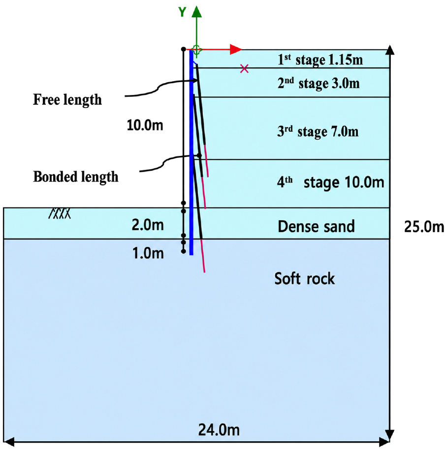
- As underground space development in urban areas increases, excavation support methods that can ensure stability within confined urban sites are becoming increasingly important. Horizontal struts occupy the excavation space, while ground anchors may extend beyond the site boundary, limiting their applicability in urban areas. In this study, staged excavation stability analysis was performed for a horizontal support-replacing anchor system. Numerical analyses were conducted under two-dimensional plane strain conditions using PLAXIS 2D, and wall horizontal displacement, ground surface settlement, and factor of safety were evaluated through staged construction analysis and the shear strength reduction method. The results showed that wall horizontal displacement increased as the anchor inclination angle increased, especially under high-angle conditions of 80° or greater. Increases in bonded length and free length reduced displacement to some extent, but their influence was limited beyond a certain length. In contrast, increasing the jacking force reduced wall horizontal displacement under the same inclination angle. In addition, comparison with field measurements indicated that the maximum horizontal displacement obtained from the analysis was larger than the measured value, indicating that the numerical analysis provided conservative estimates of wall displacement. Therefore, in the design of horizontal support-replacing anchors, the anchor inclination angle and jacking force should be considered together while satisfying the minimum bonded length and free length requirements.
- COLLAPSE
도심지 지하공간 개발이 증가함에 따라 제한된 부지 내에서 안정적으로 굴착을 수행할 수 있는 흙막이 지보 공법의 필요성이 커지고 있다. 수평 지보재는 굴착 내부 공간을 점유하고, 어스앵커는 정착장이 부지 외부로 확장될 수 있어 도심지 조건에서 적용상 한계를 가진다. 본 연구에서는 이러한 문제를 보완하기 위해 수평 지보재를 대체할 수 있는 앵커 시스템을 대상으로 굴착단계별 안정성 해석을 수행하였다. 수치해석은 PLAXIS 2D를 이용한 2차원 평면변형률 조건에서 수행하였으며, 시공단계별 해석과 전단강도 감소기법을 적용하여 벽체 수평변위, 배면 지표침하량 및 안전율을 검토하였다. 해석 결과, 앵커 설치각이 증가할수록 벽체 수평변위가 증가하였으며, 특히 80° 이상의 고각 조건에서 변위 증가가 뚜렷하였다. 정착장 및 자유장 길이 증가는 일부 변위 저감 효과를 보였으나, 일정 길이 이상에서는 그 영향이 제한적이었다. 반면 긴장력(jacking force)이 증가할수록 동일한 경사각 조건에서 벽체 수평변위가 감소하였다. 또한 현장계측 결과와 비교한 결과, 해석 최대 수평변위가 계측값보다 크게 산정되어 수치해석이 벽체 변위를 보수적으로 평가하는 경향을 보였다. 따라서 수평 지보재 대체 앵커 설계 시에는 최소 정착장 및 자유장 조건을 만족하는 범위에서 앵커 설치각과 긴장력을 함께 고려할 필요가 있다.
-
Stability Analysis of Horizontal Support-Replacing Anchors at Different Excavation Stages
-
-
Development of Ground Motion Prediction Models Using Spectral Accelerations Based on Seismic Station Data
국내 지진 계측 자료 기반 스펙트럴 가속도를 활용한 지반운동 예측 모델 개발
-
Sinhang Kang
강신항
- Earthquakes with magnitudes of greater than 5 occurred in Gyeongju and Pohang, Gyeongbuk Province, in 2016 and 2017, respectively, causing significant damage …
2016년과 2017년에 경북 경주시와 포항시에서 규모 5 이상의 지진이 발생하여 여러 피해를 유발하였으며, 지진 재해 방지를 위한 대책을 마련할 필요성이 점차 증가하고 …
- Earthquakes with magnitudes of greater than 5 occurred in Gyeongju and Pohang, Gyeongbuk Province, in 2016 and 2017, respectively, causing significant damage and increasing the need for earthquake disaster prevention measures. To quantify earthquake damage, an accurate ground motion prediction model is required. However, existing models developed in Korea faced challenges in ensuring accuracy due to a shortage of seismic observation data compared to other countries. In this study, we propose a ground motion prediction model using spectral acceleration data acquired from Korean seismic records collected from 2003 to 2025. The proposed ground motion prediction model consists of a source effect model and a path effect model, and residual analyses are additionally conducted to validate prediction accuracy. The suitability of the proposed ground motion prediction model was confirmed through the standard deviation analysis of the residuals.
- COLLAPSE
2016년과 2017년에 경북 경주시와 포항시에서 규모 5 이상의 지진이 발생하여 여러 피해를 유발하였으며, 지진 재해 방지를 위한 대책을 마련할 필요성이 점차 증가하고 있다. 지진 피해를 정량화하기 위해 정확성을 갖춘 지반운동 예측 모델이 필요하지만, 기존 국내에서 개발된 지반운동 예측 모델의 경우 국외 대비 부족한 지진 관측 자료를 기반으로 개발되어 정확성 확보에 어려움이 있었다. 본 연구에서는 2003년부터 2025년까지 발생한 국내 지진 관측소 계측 자료를 기반으로 획득한 스펙트럴 가속도 자료를 활용하여 지반운동 예측 모델을 제안하였다. 지반운동 예측 모델은 지진의 진원 효과 모델, 경로 효과 모델로 구성되었으며, 예측 모델의 적합성 검증을 위해 잔차 분석을 수행하였다. 잔차의 표준편차 분석을 통해 제안된 지반운동 예측 모델의 적합성을 확인하였다.
-
Development of Ground Motion Prediction Models Using Spectral Accelerations Based on Seismic Station Data
-
-
Analysis of the Relationship Between Underground Building Characteristics and Ground Subsidence Considering Spatial Autocorrelation
공간 자기상관을 고려한 지하 건축물 특성과 지반함몰 발생 관계 분석
-
Sungyeol Lee, Jaemo Kang, Myeongsik Kong, Jinyoung Kim, Eomzi Yang
이성열, 강재모, 공명식, 김진영, 양엄지
- Ground subsidence mainly occurs in densely populated urban areas, and it is necessary to analyze its occurrence characteristics and establish preventive management …
지반함몰은 인구 밀도가 높은 도심지에서 주로 발생하며, 사고 발생 시 인명 및 재산피해를 야기하기 때문에 사고 발생 특성을 분석하고 사전에 대응할 필요가 …
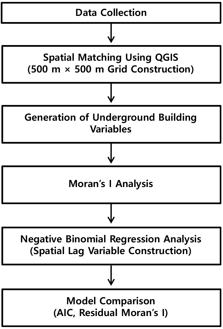
- Ground subsidence mainly occurs in densely populated urban areas, and it is necessary to analyze its occurrence characteristics and establish preventive management strategies because such accidents may cause human casualties and property damage. Studies analyzing the occurrence characteristics of ground subsidence have mainly focused on underground utility information. However, ground subsidence is a phenomenon caused by the complex interaction of multiple factors, and therefore various influencing factors should be considered. Accordingly, this study analyzed the occurrence characteristics of ground subsidence using underground building factors that can indirectly reflect the structure of urban underground spaces. For this purpose, underground building data and ground subsidence accident records from 2008 to 2016 were collected for a metropolitan urban area in the Republic of Korea, and the study area was divided into 500 m × 500 m grids using QGIS. Subsequently, datasets were constructed by extracting the number of underground buildings, the ratio of aged underground buildings, and the number of ground subsidence occurrences within each grid. In addition, Negative Binomial regression analysis and Moran’s I analysis were performed to consider the over-dispersion characteristics and spatial autocorrelation characteristics of ground subsidence occurrences. The results showed that Moran’s I for ground subsidence occurrences was 0.441 (p < 0.001), indicating the presence of spatial clustering characteristics. Furthermore, the results of the Negative Binomial regression analysis showed that the number of underground buildings, mean building age, and the ratio of underground buildings older than 20 years had statistically significant positive (+) relationships with the number of ground subsidence occurrences. In the model including the spatial autocorrelation variable, the residual Moran’s I decreased and the AIC decreased from 6213 to 5669. Therefore, it is expected that more effective analysis and management of ground subsidence risk areas can be achieved by jointly considering the distribution and aging characteristics of underground buildings together with spatial autocorrelation characteristics.
- COLLAPSE
지반함몰은 인구 밀도가 높은 도심지에서 주로 발생하며, 사고 발생 시 인명 및 재산피해를 야기하기 때문에 사고 발생 특성을 분석하고 사전에 대응할 필요가 있다. 지반함몰 발생 특성을 분석하기 위한 연구는 주로 지하매설물 정보를 중심으로 수행되어 왔으나, 지반함몰은 다양한 원인이 복합적인 작용에 의해 발생하는 현상이므로 다양한 인자를 고려할 필요가 있다. 따라서 본 연구에서는 도시 지하공간 구조를 간접적으로 반영할 수 있는 지하 건축물 인자를 활용하여 지반함몰 발생 특성을 분석하였다. 이를 위하여 대한민국 대도시를 대상으로 지하 건축물 데이터와 2008~2016년 지반함몰 사고이력 데이터를 수집하였으며, QGIS를 활용하여 500 m × 500 m 크기의 grid로 구분하였다. 이후 grid 내부에 포함된 지하 건축물 개수, 노후 건축물 비율 및 지반함몰 발생횟수를 추출하여 데이터셋을 구축하였다. 또한 지반함몰 발생횟수의 과분산 특성과 공간적 자기상관 특성을 고려하기 위하여 Negative Binomial 회귀분석과 Moran’s I 분석을 수행하였다. 분석 결과, 지반함몰 발생횟수에 대한 Moran’s I는 0.441(p < 0.001)로 나타나 공간적 군집 특성이 존재하는 것으로 확인되었다. 또한 Negative Binomial 회귀분석 결과, 지하 건축물 개수와 평균 활용년수, 20년 이상 노후 건축물 비율 변수는 지반함몰 발생횟수와 통계적으로 유의한 양(+)의 관계를 나타내는 것으로 확인되었다. 공간 자기상관 변수를 추가한 모델에서는 잔차 Moran’s I가 감소하고 AIC가 6213에서 5669로 감소하는 것으로 나타났다. 따라서 지하 건축물의 분포 및 노후 특성과 공간 자기상관 특성을 함께 반영할 경우 보다 효과적인 지반함몰 위험지역 분석 및 관리가 가능할 것으로 기대된다.
-
Analysis of the Relationship Between Underground Building Characteristics and Ground Subsidence Considering Spatial Autocorrelation
-
-
A Study on Wave Interaction with a Bottom-Mounted Cylindrical Offshore Structure
해저에 설치된 실린더 형 해상구조물과 파랑의 상호작용에 관한 연구
-
Hyunju Na, Hojin Lee, Sungduk Kim
나현주, 이호진, 김성덕
- The purpose of the present study is to predict the water surface wave diffraction due to quadruple bottom mounted vertical cylinders. The …
본 연구의 목적은 해저에 고정된 4개의 수직 원통에 의한 수면파의 회절 현상을 예측하는 것이다. 해석 대상인 파동장은 2차원 평면으로 가정하였으며, 원통의 배치는 …
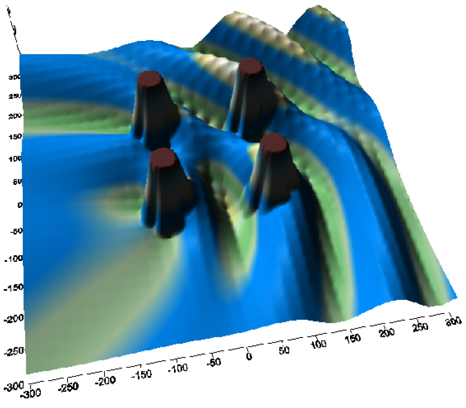
- The purpose of the present study is to predict the water surface wave diffraction due to quadruple bottom mounted vertical cylinders. The wave field of the problem is considered to be a two dimensional plane and the configurations of the cylinders are designated by quadruple circular system. The numerical method for simulating waves are developed using the solution of the Green function based on the two-dimensional boundary integral approach. Through this numerical model, wave diffractions at the interested region have been illustrated for various conditions related with center-to-center spacing of quadruple cylinders, incident wave angle, and diameter of cylinders. Through the simulations, it was concluded that this numerical model is an accurate and efficient tool to predict the wave field of bottom mounted offshore structures.
- COLLAPSE
본 연구의 목적은 해저에 고정된 4개의 수직 원통에 의한 수면파의 회절 현상을 예측하는 것이다. 해석 대상인 파동장은 2차원 평면으로 가정하였으며, 원통의 배치는 4개의 원형 실린더가 구성하는 시스템으로 설정하였다. 파동을 모의하기 위한 수치 해석 기법은 2차원 경계 적분법에 기초한 그린 함수(Green function) 해를 이용하여 개발되었다. 이 수치 모델을 통해 원통 간 중심 거리, 입사파의 각도, 원통의 직경 등 다양한 조건에 따른 관심 영역 내 파동 회절 특성을 분석하였다. 시뮬레이션 결과, 본 수치 모델은 해저 고정식 해양 구조물 주변의 파동장을 예측하는 데 있어 정확하고 효율적인 도구임이 확인되었다.
-
A Study on Wave Interaction with a Bottom-Mounted Cylindrical Offshore Structure

Journal Informaiton
 Journal of the Korean Geo-Environmental Society
Journal of the Korean Geo-Environmental Society


한국지반환경공학회
Suite 603, Yangji B/D, 1397, Yangjae-daero, Gangdong-gu, Seoul 05376, Korea
Tel: +82-2-483-7888 / Fax: +82-2-483-7830 / E-mail: kges7888@hanmail.net Copyright© Korean Geo-Environmental Society. Powered by APUB
Tel: +82-2-483-7888 / Fax: +82-2-483-7830 / E-mail: kges7888@hanmail.net Copyright© Korean Geo-Environmental Society. Powered by APUB