
-
-
Study on Characteristic of Liquefaction Resistance of Busan’s Coastal Sand
부산 해안 모래의 액상화 저항 특성에 관한 연구
-
Donghun Lee, Joohyun Lee, Jongchan Yoon, Jinman Kim
이동훈, 이주현, 윤종찬, 김진만
- Since 2016, earthquakes with magnitudes greater than 5.0 recorded in Korea include the July 2016 Ulsan offshore earthquake, the September 2016 Gyeongju …
2016년 이후 국내에서 관측된 규모 5.0 이상의 지진으로는 2016년 7월 울산 동구 해역 지진, 2016년 9월 경주 지진, 2017년 11월 포항 지진이 …
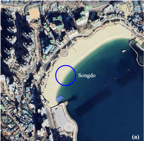
- Since 2016, earthquakes with magnitudes greater than 5.0 recorded in Korea include the July 2016 Ulsan offshore earthquake, the September 2016 Gyeongju earthquake, and the November 2017 Pohang earthquake, all of which occurred in regions geographically close to Busan. In particular, the magnitude 5.4 earthquake that struck Pohang on November 15, 2017, officially reported localized evidence of soil liquefaction. Accordingly, this study conducted a systematic evaluation of liquefaction resistance characteristics for the Busan area, where coastal reclaimed land and sandy deposits are widely distributed. In this study, four representative coastal sites in Busan (Songdo, Haeundae, Songjeong, and Ilgwang) were selected, and in-situ sand samples were collected for laboratory testing. The samples were tested under specified relative density and effective confining pressure conditions using a direct simple shear (DSS) apparatus to perform cyclic simple shear tests. Liquefaction triggering conditions were evaluated by progressively increasing the cyclic stress ratio (CSR). In addition, the cyclic resistance ratio (CRR) was derived from the test results to compare and analyze liquefaction resistance characteristics among the sites. The results showed that among the four sites, the sands from Haeundae exhibited the lowest CRR value. Grain size distribution analysis further indicated that this sample falls within a particle size range generally considered susceptible to liquefaction.
- COLLAPSE
2016년 이후 국내에서 관측된 규모 5.0 이상의 지진으로는 2016년 7월 울산 동구 해역 지진, 2016년 9월 경주 지진, 2017년 11월 포항 지진이 있으며, 이들 모두 부산과 지리적으로 인접한 지역에서 발생하였다. 특히 2017년 11월 15일 경북 포항에서 발생한 규모 5.4 지진의 경우, 공식 보고를 통해 액상화 현상에 대한 흔적이 일부 확인된 바 있다. 이에 따라 해안 매립지 및 사질지반이 광범위하게 분포하는 부산 지역을 대상으로, 지진으로 인한 액상화 저항 특성에 관한 체계적인 평가를 수행하였다. 본 연구에서는 부산광역시 연안의 대표 지점 4개소(송도, 해운대, 송정, 일광)를 선정하고, 각 지점에서 원지반 모래 시료를 채취하여 실내 시험을 수행하였다. 채취 시료는 설정된 상대밀도와 유효구속압 조건에서 직접단순전단(DSS, direct simple shear) 장비를 이용하여 반복단순전단시험을 실시하였으며, 진동저항응력비(CSR, cyclic stress ratio)를 단계적으로 증가시키면서 액상화 발생 조건을 평가하였다. 또한 시험 결과로부터 액상화 전단저항응력비(CRR, cyclic resistance ratio)를 산정하여 대상 지점 간 액상화 저항 특성을 비교·분석하였다. 그 결과, 4개 지점 중 해운대 모래의 CRR이 가장 낮게 나타났으며, 입도분포 분석 결과 해당 시료는 일반적으로 액상화에 취약한 입도 범위에 포함됨을 확인하였다.
-
Study on Characteristic of Liquefaction Resistance of Busan’s Coastal Sand
-
-
Reusability Evaluation of Existing Concrete Piles in Soft Ground
연약지반에 설치된 기존 콘크리트 말뚝의 재사용 가능성 평가
-
Youngho Seo, Sunhee Kim, Jungsoon Hwang, Jungjae Lee, Seungcheol Baek
서영호, 김선희, 황정순, 이중재, 백승철
- This study employed numerical analysis to identify potential issues associated with two scenarios for the removal of existing concrete piles originally installed …
기존에 계획된 구조물의 기초용으로 시공된 콘크리트 말뚝을 철거하기 위해 임시 굴착공사와 되메움 공사가 진행됨에 따라 발생할 수 있는 위해요인 및 굴착 대상 …
- This study employed numerical analysis to identify potential issues associated with two scenarios for the removal of existing concrete piles originally installed as foundations for a planned structure. Considering hazard factors that may arise from temporary excavation and backfilling operations, as well as the geotechnical characteristics of the excavation ground and the surrounding groundwater conditions, the analysis compared (i) complete removal of all piles and (ii) staged removal of only the necessary portions around the building. In addition, displacements at each construction stage were evaluated for both scenarios to predict their effects on adjacent ground and structures. The results indicate that decisions regarding pile removal should be made with careful consideration of site-specific ground conditions and groundwater distribution. Furthermore, the carbon emission analysis indicated that the complete removal of the piles results in an additional emission of approximately 9,585 ton-CO2eq. Regarding the reforestation required for carbon neutrality, it was verified that a period of 60 years must elapse following the planting of 76,680 pine trees.
- COLLAPSE
기존에 계획된 구조물의 기초용으로 시공된 콘크리트 말뚝을 철거하기 위해 임시 굴착공사와 되메움 공사가 진행됨에 따라 발생할 수 있는 위해요인 및 굴착 대상 지반특성, 주변 지하수 특성을 고려하여 말뚝을 전체 철거하는 경우와 건축물을 중심으로 필요한 부분만 단계적으로 철거하는 경우 발생 가능한 문제점을 수치해석을 통해 분석하였다. 또한, 말뚝 전체를 철거할 경우와 필요한 부분만 철거하는 경우 시공 단계별 변위를 확인하여 인접 지반 및 구조물에 미칠 영향을 예측하였다. 추가적으로 환경영향 평가를 위해 탄소배출량을 산정한 결과, 말뚝 전체 철거시 기존 재사용안 대비 약 9,585 ton-CO2eq. 의 탄소가 추가 배출되는 것으로 분석되었다. 이는 소나무 76,680그루를 식재한 후 60년 동안 흡수해야 하는 양에 해당한다. 결과적으로 기존 말뚝의 철거를 최소화하는 재 사용안은 안정성, 환경성, 경제성 측면에서 모두 우수한 것으로 평가되었다.
-
Reusability Evaluation of Existing Concrete Piles in Soft Ground
-
-
Study of Korean-Style Deep Geological Repository Layout for Conceptual Technology Establishment of HLRW Disposal Facilities
고준위 방사성폐기물(HLRW) 처분시설의 개념 정립을 위한 한국형 심층처분시설 배치 연구
-
Hyoil Kim, Cheongmoon Kim, Byungchan Joo, Kiljung Kim, Kwangsoon Choi, Jaisung Yoo
김효일, 김청문, 주병찬, 김길정, 최광순, 유재성
- A deep geological disposal facility for high-level radioactive waste (HLRW) must balance environmental impact, repository stability, constructability, and cost. The study evaluates …
고준위 방사성폐기물(HLRW) 심층처분시설은 환경영향 최소화, 처분터널 안정성, 시공 효율, 경제성을 동시에 만족하도록 설치되어야 한다. 핵심 변수는 처분터널의 중심간격(CTC 25, 30, 40 m)이며, …
- A deep geological disposal facility for high-level radioactive waste (HLRW) must balance environmental impact, repository stability, constructability, and cost. The study evaluates key layout parameters - especially the center-to-center spacing of parallel disposal tunnels (CTC 25, 30, and 40 m) - using consistent assumptions and multiple indicators, including excavation volume, required underground footprint, construction period, blasting-vibration effects, and numerical tunnel stability. With a 97 °C canister surface-temperature limit, the minimum PWR SNF disposal-hole spacing is estimated as 9.0, 8.0, and 6.5 m for CTC 25, 30, and 40 m, respectively. Compared with the 25 m case, total excavation is reduced to about 92 % and 83 % for 30 m and 40 m spacing, while the footprint increases by about 6 % and 18 %. Larger spacing also improves constructability: tunneling duration decreases to 93 % and 71 %, and adjacent-tunnel blasting vibrations decrease to 75 % and 47 %. Numerical analyses confirm that at 40 m spacing, crown settlement, inner displacement, and shotcrete compressive stress drop to 67, 45, and 20 % relative to 25 m spacing, indicating meaningful stability gains. Overall, despite a modest increase in site area, a 40 m disposal-tunnel spacing with 6.5 m disposal-hole spacing is recommended as the most efficient conceptual arrangement for Korean HLRW disposal facilities. This paper proposes an optimal “Korean-style” conceptual layout reflecting the Korean Peninsula’s mountainous terrain, where portals and access/vertical disposal tunnels are typically located near mountain foothills to secure sufficient overburden while minimizing access-tunnel length and separating waste-handling areas from construction zones.
- COLLAPSE
고준위 방사성폐기물(HLRW) 심층처분시설은 환경영향 최소화, 처분터널 안정성, 시공 효율, 경제성을 동시에 만족하도록 설치되어야 한다. 핵심 변수는 처분터널의 중심간격(CTC 25, 30, 40 m)이며, 굴착량, 지하 점유면적(시설배치면적), 공사기간(굴진기간) 대리지표, 암반 발파 규모에 따른 진동, 그리고 수치해석 기반 터널 안정성(변위·지보재 응력)을 종합 지표로 사용하였다. 캐니스터 표면온도를 97 ℃로 제한할 때 PWR형 사용후핵연료(SNF)의 처분공 최소 간격은 CTC 25, 30, 40 m에서 각각 9.0, 8.0, 6.5 m로 산정된다. 25 m 대비 터널 간격을 30 m와 40 m로 확대하면 총 굴착량은 약 92 %와 83 %로 감소하지만, 요구 점유면적은 약 6 %와 18 % 증가한다. 반면 시공성 측면에서 굴진 공기는 93 %와 71 %로 단축되고, 인접 터널 발파 진동값이 75 %와 47 % 수준으로 감소한다. 수치해석 결과 40 m 간격에서는 천단침하, 내공변위, 숏크리트 압축응력이 각각 67, 45, 20 %로 낮아져 안정성이 크게 향상됨이 확인되었다. 결론적으로 부지면적이 다소 증가하더라도 안정성, 시공 효율, 경제성 측면을 종합 고려할 때 CTC 40 m와 처분공 간격 6.5 m 조합을 한국형 HLRW 처분시설 개념기술 확립 단계의 효율적 개념 배치로 제안한다. 또, 한반도의 급경사 산악지형과 평탄지 부족 등 국내 지형적 특성을 반영한 ‘한국형’ 개념 배치를 제시하고, 산기슭에 터널 출입구를 두어 충분한 피복심도를 확보하면서 접근터널 길이를 최소화하며, 방사성물질 취급구역과 시공구역을 분리하는 구성을 전제로 최적 예비 배치안을 제시하였다.
-
Study of Korean-Style Deep Geological Repository Layout for Conceptual Technology Establishment of HLRW Disposal Facilities
-
-
Estimation of Random Walk Model Parameters Using Global Optimization Technique
전역최적화 기법을 통한 RWM 최적 매개변수 추정
-
Chanul Choi, Song Eu, Mingeun Song, Giha Lee
최찬울, 유송, 송민근, 이기하
- This study proposes an automated framework to estimate optimal parameters of the probabilistic Random Walk Model (RWM) for rapid debris-flow runout mapping. …
본 연구는 토석류 피해범위를 신속하게 추정하기 위해 확률 기반 Random Walk Model(RWM)의 최적 매개변수(VS, IW, SS)를 전역최적화 기법으로 자동 추정하는 방법을 제안하였다. …
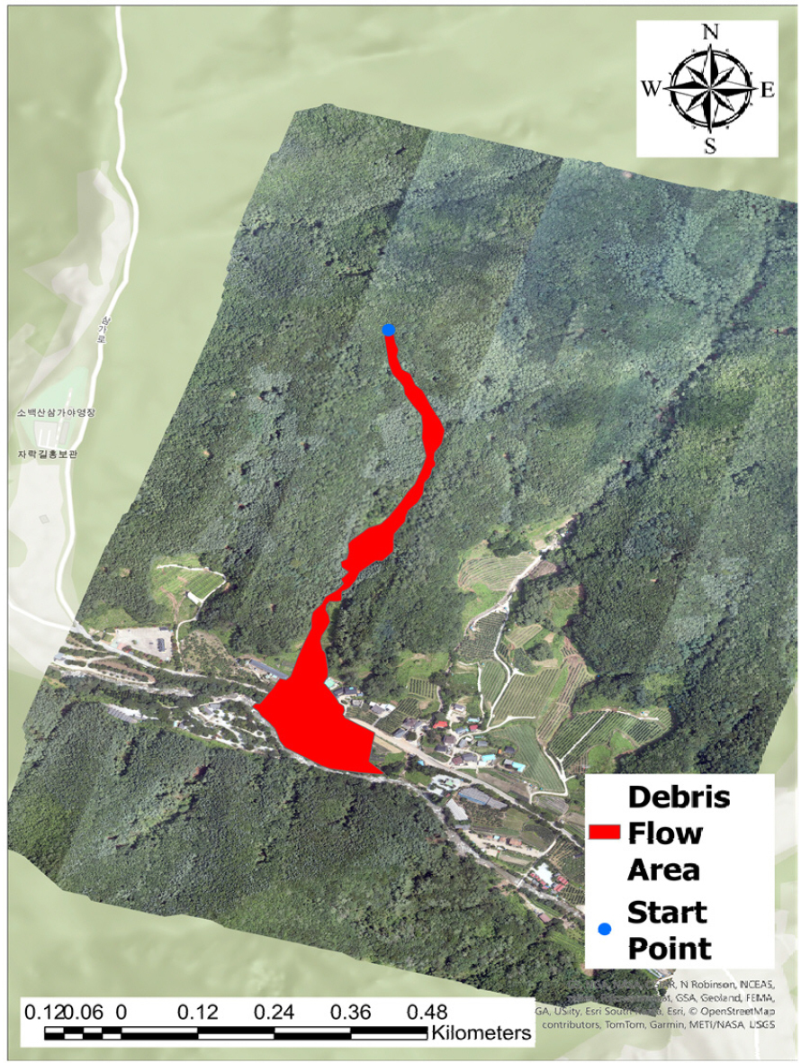
- This study proposes an automated framework to estimate optimal parameters of the probabilistic Random Walk Model (RWM) for rapid debris-flow runout mapping. The workflow relies on minimal inputs: a 5 m resolution DEM, mapped debris-flow damage and initiation points, and a binary damage/non-damage map for evaluation. The method was applied to Samga-ri, Punggi-eup, Yeongju-si (Gyeongsangbuk-do, Republic of Korea), where a large debris-flow event occurred during heavy rainfall on July 15, 2023. To reduce the time burden and potential local-optimum bias of manual tuning, a Differential Evolution–based global optimization module was developed to calibrate VS, IW, and SS. The optimized parameters were VS=18.509, SS=6.849, and IW=2.822, yielding a mean IoU of 0.3228±0.0047, precision of 0.5942, and recall of 0.4361. The relatively low IoU and recall are attributed to the RWM structure, which evaluates outcomes mainly at final deposition cells rather than the full travel path. The mean deposition pattern was consistent with post-event aerial imagery, and the maximum deposition height was approximately 3.8 m. In addition, a pass-count-based pass probability analysis showed that simulated flows were concentrated along the observed damage corridor, indicating that flow-path tendencies can be inferred even with a simplified probabilistic model.
- COLLAPSE
본 연구는 토석류 피해범위를 신속하게 추정하기 위해 확률 기반 Random Walk Model(RWM)의 최적 매개변수(VS, IW, SS)를 전역최적화 기법으로 자동 추정하는 방법을 제안하였다. 입력자료는 5 m 해상도 DEM, 토석류 피해지역 및 시작 지점 자료, 피해/비피해 이진 분류 맵으로 구성하였다. 연구 대상지는 2023년 7월 15일 집중호우로 대규모 토석류 피해가 발생한 경상북도 영주시 풍기읍 삼가리 지역이며, 수동 보정의 시간 소요 및 국소 최적해 불확실성을 줄이기 위해 차분진화(Differential Evolution) 기반 최적화 모듈을 개발하였다. 최적화 결과 VS=18.509, SS=6.849, IW=2.822가 추정되었고, 평균 IoU 0.3228±0.0047, 정밀도 0.5942, 재현율 0.4361을 보였다. IoU와 재현율이 낮은 원인은 이동 경로를 누적하지 않고 최종 퇴적 셀 중심으로 평가되는 RWM 특성으로 해석되었다. 평균 퇴적량은 항공사진 기반 피해 양상과 유사했고 최대 퇴적 높이는 약 3.8 m였다. 또한 통과횟수 기반 통과확률 분석에서 실제 피해 경로를 따라 토석류 이동이 집중되는 경향이 확인되어, 단순 확률 모형에서도 흐름 경향 파악이 가능함을 제시하였다.
-
Estimation of Random Walk Model Parameters Using Global Optimization Technique

Journal Informaiton
 Journal of the Korean Geo-Environmental Society
Journal of the Korean Geo-Environmental Society


한국지반환경공학회
Suite 603, Yangji B/D, 1397, Yangjae-daero, Gangdong-gu, Seoul 05376, Korea
Tel: +82-2-483-7888 / Fax: +82-2-483-7830 / E-mail: kges7888@hanmail.net Copyright© Korean Geo-Environmental Society. Powered by APUB
Tel: +82-2-483-7888 / Fax: +82-2-483-7830 / E-mail: kges7888@hanmail.net Copyright© Korean Geo-Environmental Society. Powered by APUB